Common names from other countries
Classification / Names / Names
Nomi Comuni | Sinonimi | Catalog of Fishes (gen., sp.) | ITIS | CoL | WoRMS
Environment: milieu / climate zone / depth range / distribution range
Ecologia
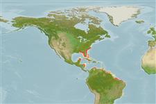
Demersale; acqua dolce; salmastro; distribuzione batimetrica 0 - 13 m (Ref. 116169), usually 2 - 5 m (Ref. 81178). Tropical; 38°N - 21°S, 89°W - 35°W
Western Atlantic: Trichechus manatus manatus: from the coasts and rivers of Mexico to as far south to Rio Doce, Brazil including the Orinoco and Amazon; Trichechus manatus latirostris: from the Florida Peninsula to Rhode Island. Tropical to temperate.
Length at first maturity / Size / Peso / Age
Maturity: Lm ? range ? - ? cm Max length : 390 cm TL maschio/sesso non determinato; (Ref. 1394); Peso massimo pubblicato: 1.6 t (Ref. 1394)
Found in coastal marine, brackish and freshwater areas. Feeds on aquatic plants, (i.e. water hyacinths and marine seagrasses, algae, parts of mangrove trees, floating and shoreline vegetation); invertebrates (i.e. tunicates); and fish they remove from fishing nets (Ref. 1394). Found in coastal marine, brackish and freshwater areas (Ref. 1394), where primary habitat consists of rivers, coastal lagoons and bays and mangrove islands (Ref. 86755). Feeds on aquatic plants, (i.e. water hyacinths and marine seagrasses, algae, parts of mangrove trees, floating and shoreline vegetation); invertebrates (i.e. tunicates); and fish they remove from fishing nets (Ref. 1394).
Jefferson, T.A., S. Leatherwood and M.A. Webber. 1993. (Ref. 1394)
IUCN Red List Status (Ref. 130435)
CITES status (Ref. 108899)
Human uses
Pesca: commerciale
FAO - pesca: species profile | FishSource | Sea Around Us
Strumenti
Informazioni ulteriori
Age/Size
Accrescimento
Length-weight
Length-length
Morfologia
Larve
Abbondanza
Fonti Internet
Estimates based on models
Preferred temperature
(Ref.
115969): 22.9 - 28, mean 26.5 (based on 562 cells).
Vulnerability
Very high vulnerability (90 of 100).
Price category
Unknown.


")